GPS
Warning
Important Notice Regarding Firmware Version 6.6.0 and above
- Feature Integration: Starting with router firmware version 6.6.0, the functionality of this Router App is included as a standard feature. It can be accessed via Configuration → Services → GNSS and partially through Configuration → Services → SNMP.
- Recommendation: On routers running version 6.6.0 or newer, use the native firmware feature and uninstall this app to prevent potential conflicts.
- Migration Advisory: When transitioning from this app to the integrated feature, you must carefully review the new settings. Default values and available options may differ, and failing to adjust them could lead to unexpected reboot behavior.
The GPS (Global Positioning System) Router App allows your router to provide location and time information in all weather conditions, anywhere on or near the Earth, where there is an unobstructed line of sight to four or more GPS satellites.
This Router App is compatible with all Advantech routers equipped with GNSS functionality. The type of GSM/GNSS module installed in the router can be found in the web interface at Status → Mobile WAN → Mobile Network Information → Model.
Tips
For routers that share a cellular connector with the GNSS connection, diversity cellular reception is not supported when the GNSS antenna is connected.
Web Interface
The left part of the web interface contains the menu with pages for monitoring (Status), Configuration, Information, and Customization of the router. The Information block contains the Licenses item, where used licenses are displayed. The Customization block contains only the Return item, which switches the GPS web interface to the main router interface.
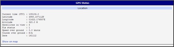
Location
If the device has an unobstructed line of sight to four or more GPS satellites, detailed information about the accurate location of the device (router) is available.
| Item | Description |
|---|---|
| Current time (UTC) | Current time in hhmmss.0 format (Coordinated Universal Time) |
| Latitude | Geographic coordinate specifying the north-south position (in ddmm.mmmmmmG format where d stands for degrees, m for minutes, and G for geographical direction [N, S]) |
| Longitude | Geographic coordinate specifying the east-west position (in dddmm.mmmmmmG format where d stands for degrees, m for minutes, and G for geographical direction [E, W]) |
| Altitude | Height above sea level of a location (in meters) |
| Satellites in view | Number of satellites directly visible to the router |
| Fix status | Indicates data availability and quality. 0 indicates no data. A non-zero value indicates the presence of data. |
| Speed over ground | Current speed of the router relative to Earth's surface (in knots) |
| Course over ground | The actual course the router is moving along at the moment relative to Earth's surface (in degrees) |
| Date | Current date in ddmmyy format |
Location information
There is a clickable item called Show on map at the bottom of the window that displays the exact location of the Advantech router on Google Maps in a new tab.
System Log
In case of any problems, the system log can be viewed by pressing the System Log menu item. Detailed reports from individual applications running on the router are displayed. Use the Save button to save the system log to the computer.
The System Log default size is 1000 lines. After reaching 1000 lines, a new file is created for storing the system log. After the second file reaches 1000 lines, the first file is deleted and a new one is created.
Global
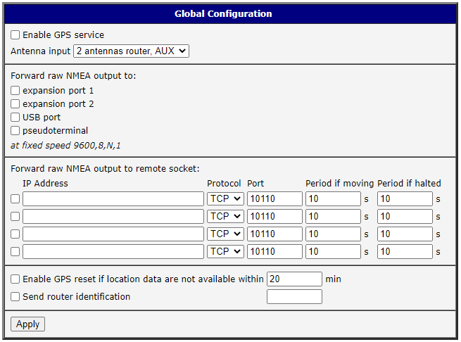
After clicking the Global item in the configuration part of the menu, a form appears that allows you to activate the GPS service by checking the Enable GPS service item. In the next part of this form, you can choose the port used for sending data from the GPS. You can select from the following options: expansion port 1, expansion port 2, USB port, and pseudoterminal /dev/nmea. Expansion port 1 and expansion port 2 are optional ports of the router. Data is stored in raw NMEA format.
The configuration form also allows the router to forward raw NMEA output to a remote socket. In this case, it is necessary to check the box in front of the "configuration line" and define the following information:
| Item | Description |
|---|---|
| IP Address | IP address to which the raw NMEA output will be forwarded |
| Protocol | The protocol by which raw NMEA output will be sent |
| Port | Port on which the communication will be underway |
| Period if moving | Forwarding period when moving |
| Period if halted | Forwarding period when halted |
Forwarding data to a remote socket
At the bottom of the form, you can enable the automatic reset of GPS. This is performed when location data is unavailable within a set number of minutes.
The last item configures the router's identification. When switched on, the identification string $GPFID, RouterIdentificationString is sent in every NMEA batch. The +RouterIdentificationString is the string configured in the web interface.
GPSD
The GPSD form can be displayed by selecting the GPSD item in the configuration part of the menu. If the Enable GPSD daemon option is checked, the router automatically starts listening on the port specified below.
| Item | Description |
|---|---|
| Inner port | Port in device dedicated for GPS |
| Listen port | TCP/IP port on which to listen for GPSD clients (default is 2947) |
GPSD configuration

SNMP
The SNMP form can be displayed by selecting the SNMP item in the configuration part of the menu. If the Enable reporting to supervisory system option is checked, the router automatically sends messages to the supervisory system at the specified periods.
| Item | Description |
|---|---|
| IP Address | Destination IP address |
| Period if moving | Interval of sending messages to the supervisory system (in seconds) while in motion |
| Period if halted | Interval of sending messages to the supervisory system (in seconds) when not moving (velocity is 0) |
SNMP configuration
For sending GPS messages, the following range of OIDs is used. The importance of individual items is described in the location information table above.

| OID | Designation |
|---|---|
| .1.3.6.1.4.1.30140.7.1.0 | gpsTimeUTC |
| .1.3.6.1.4.1.30140.7.2.0 | gpsLatitude |
| .1.3.6.1.4.1.30140.7.3.0 | gpsLongitude |
| .1.3.6.1.4.1.30140.7.4.0 | gpsAltitude |
| .1.3.6.1.4.1.30140.7.5.0 | gpsSatellites |
| .1.3.6.1.4.1.30140.7.6.0 | gpsFixStatus |
| .1.3.6.1.4.1.30140.7.7.0 | gpsSpeedOverGround |
| .1.3.6.1.4.1.30140.7.8.0 | gpsCourseOverGround |
| .1.3.6.1.4.1.30140.7.9.0 | gpsDate |
GPS OIDs
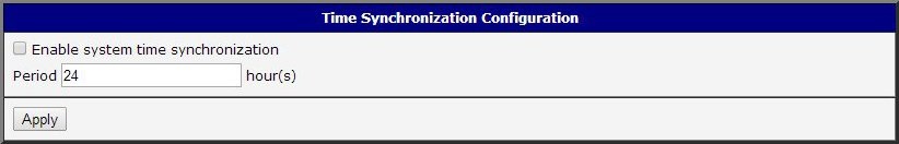
Time Synchronization
The form for synchronization of the system time can be invoked by pressing the Time Synchronization item in the configuration part of the web interface menu. The Enable system time synchronization check box is used to activate automatic time synchronization. The number of hours after which the synchronization is performed must be defined in the box below.
Licenses
This section lists the Open-Source Software (OSS) licenses used by this Router App.
